
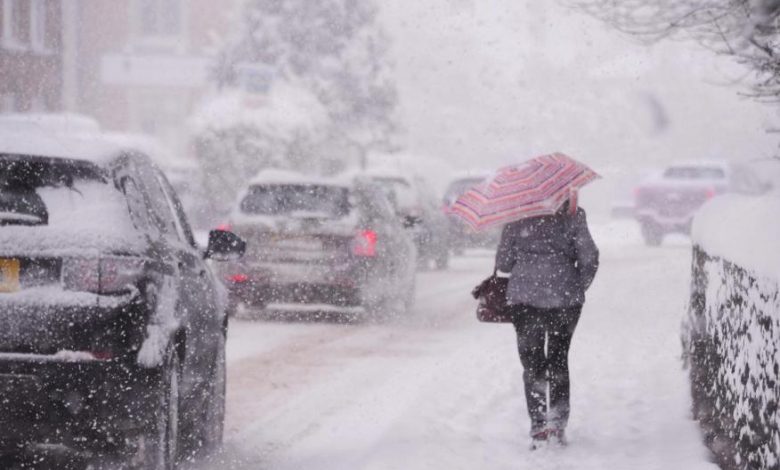
A weather warning has been issued for the entire region, lasting from 5pm on Thursday until 11am on Friday. The warning is due to rain and wintry showers that will lead to icy patches forming on roads, pavements, and cycle paths. This could result in longer journey times for drivers and delays for trains. The Met Office has advised drivers to take extra caution and avoid traveling in heavy snow and icy conditions if possible, as there is a risk of injuries due to slips and falls on icy surfaces. Temperatures have dropped as a cold north-easterly wind brings Arctic air down from Scandinavia, and overnight temperatures are expected to remain below freezing heading into the weekend.
The Met Office has also forecast heavier snow across Norfolk towards the end of the week, as a cold front meets an area of low pressure moving in from the southwest. This combination of weather systems is likely to cause further disruption, with adverse conditions expected to persist through the week. As a result of the severe weather, seal pups in the region are in critical condition after being ripped from their mothers during the storms. The Arctic air mass and wintry showers have caused temperatures to plummet, leading to dangerous icy conditions and the possibility of further injuries due to slips and falls. It is important for residents to stay updated on weather reports and take necessary precautions to avoid accidents and travel disruptions.
It is crucial for residents in the region to be aware of the weather warning and take necessary measures to stay safe. This includes being mindful of the icy conditions and taking precautions to prevent slips and falls. Drivers are advised to take extra care on the roads and consider avoiding travel in heavy snow and icy conditions if possible. The cold front from the north-east, combined with low-pressure systems from the southwest, is expected to bring heavier snow towards the end of the week, leading to potential further disruption and dangerous conditions. As temperatures are expected to remain below freezing heading into the weekend, it is important for residents to stay informed about the weather forecasts and to be prepared for continued wintry conditions.


I love your blog.. very nice colors & theme. Did you design this website yourself or did you hire someone to do it for you? Plz answer back as I’m looking to create my own blog and would like to find out where u got this from. cheers
Magnificent beat ! I would like to apprentice while you amend your website, how could i subscribe for a blog site? The account aided me a acceptable deal. I had been tiny bit acquainted of this your broadcast provided bright clear concept
There are some interesting closing dates on this article but I don’t know if I see all of them heart to heart. There may be some validity but I’ll take maintain opinion till I look into it further. Good article , thanks and we wish more! Added to FeedBurner as nicely
Hiya! Quick question that’s completely off topic. Do you know how to make your site mobile friendly? My site looks weird when viewing from my apple iphone. I’m trying to find a template or plugin that might be able to resolve this problem. If you have any suggestions, please share. Many thanks!
I was very pleased to find this web-site.I wanted to thanks for your time for this wonderful read!! I definitely enjoying every little bit of it and I have you bookmarked to check out new stuff you blog post.
It’s actually a nice and helpful piece of info. I am happy that you shared this helpful info with us. Please stay us up to date like this. Thanks for sharing.
Hi! I know this is kinda off topic nevertheless I’d figured I’d ask. Would you be interested in exchanging links or maybe guest writing a blog post or vice-versa? My site addresses a lot of the same topics as yours and I feel we could greatly benefit from each other. If you are interested feel free to shoot me an e-mail. I look forward to hearing from you! Terrific blog by the way!
Very wonderful visual appeal on this website , I’d rate it 10 10.
Hello, Neat post. There’s an issue along with your web site in internet explorer, would test this… IE nonetheless is the marketplace leader and a large component of other people will miss your fantastic writing because of this problem.
I was very pleased to seek out this internet-site.I wanted to thanks on your time for this wonderful learn!! I positively enjoying each little bit of it and I’ve you bookmarked to check out new stuff you weblog post.
I love assembling utile info, this post has got me even more info! .
I enjoy the efforts you have put in this, appreciate it for all the great articles.
Your style is so unique compared to many other people. Thank you for publishing when you have the opportunity,Guess I will just make this bookmarked.2
Pretty portion of content. I simply stumbled upon your web site and in accession capital to assert that I get in fact enjoyed account your blog posts. Any way I will be subscribing to your augment or even I achievement you get admission to persistently fast.
I don’t even know the way I ended up here, however I believed this post was once good. I do not understand who you’re however certainly you’re going to a famous blogger in case you aren’t already 😉 Cheers!
This design is wicked! You obviously know how to keep a reader entertained. Between your wit and your videos, I was almost moved to start my own blog (well, almost…HaHa!) Fantastic job. I really enjoyed what you had to say, and more than that, how you presented it. Too cool!
Right now it looks like BlogEngine is the top blogging platform available right now. (from what I’ve read) Is that what you’re using on your blog?
It is really a nice and helpful piece of information. I am glad that you shared this helpful information with us. Please keep us up to date like this. Thank you for sharing.
F*ckin’ amazing things here. I’m very glad to see your post. Thanks a lot and i am looking forward to contact you. Will you please drop me a mail?
You made a number of fine points there. I did a search on the subject and found nearly all folks will go along with with your blog.
Hey There. I found your blog using msn. This is an extremely well written article. I’ll be sure to bookmark it and come back to read more of your useful information. Thanks for the post. I will certainly comeback.
Appreciate it for this post, I am a big big fan of this internet site would like to continue updated.
Rattling excellent info can be found on weblog. “Even if happiness forgets you a little bit, never completely forget about it.” by Donald Robert Perry Marquis.